
-
-
-
-
-

-
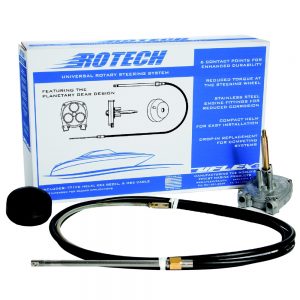
 1 × $78.27
 -
 1 × $33.00
 -
-
-
 1 × $17.99
 -
-
-
-
 1 × $29.99
 -
 2 × $84.99
 -

-
 1 × $514.99
 -
 1 × $8.99
 -
 1 × $2,099.99
 -
 1 × $361.24
 -
 1 × $18.49
 -
 1 × $54.00
 -
-
 1 × $125.00
 -
-

-
 1 × $114.99
 -
-
-
 1 × $20.11
 -
-
 1 × $1,012.15
 -

-
-
-
-
-

-
-

-
 1 × $11,659.95
 -
-
-
-
 1 × $12.68
 -
-
-
 1 × $298.49
 -
-
 2 × $85.00
 -
-
-
 1 × $152.14
 -
 1 × $35.00
 -
 1 × $114.99
 -
-
 1 × $1,654.95
 -
 1 × $314.75
 -
 1 × $479.99
 -
-

-

-
 1 × $44.99
 -
 1 × $109.95
 -
-

-

-

-
 1 × $469.99
 -
 1 × $166.50
 -

-

-
-
-
 1 × $1,055.85
 -
 1 × $961.99
 -
 1 × $1,110.00
 -
-
 1 × $429.99
 -
 1 × $229.00
 -
 1 × $1,390.00
 -
-
 1 × $120.86
 -
 1 × $107.55
 -
 1 × $1,084.00
 -
-
 1 × $48.46
 -
 1 × $11.99
 -
-

-

-
 1 × $60.00
 -
 1 × $6,374.24
 -
 1 × $479.99
 -
 1 × $49.99
 -

-
 1 × $685.71
 -
 1 × $1,393.00


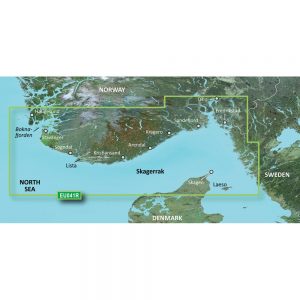
4D SA-D500 Costa Rica to Chile to Falklands
C-MAP charts have long been held in high regard by boaters because they combine aesthetically pleasing vector electronic charts with reliable sources. With the backing of Jeppesen’s parent company Boeing, a well-respected multibillion dollar global company, boaters can be assured that C-MAP charts are of the highest standard.
C-Map 4D will provide boaters with charts packed additional features such as raster chart views or Satellite images to maximize situational awareness.
Coverage Area:
Costa Rica to Chile and the Falklands
Features:
- Vector cartography
- Tidal heights
- Currents/Tidal flows
- Animated currents
- Marina charts
- C-Marina ports database
- California MPAs
- Coastal Roads
- Aerial Photos
- Land Elevations
- NavAids
- Multi-language charts
- TrueType font
- Depth Contours
- Online updates
- Explorer® charts
- Wavey Line charts
Additional information
| Weight | 0.1 lbs |
|---|---|
| Dimensions | 10 × 6 × 1 in |
| Brand | |
| Country |


