
-
-
-
-
 1 × $129.99
 -
-
 1 × $209.14
 -
-
 1 × $2,039.49
 -
-
 1 × $12.82
 -
-
 1 × $34.99
 -
 1 × $141.44
 -
-
-
 2 × $685.71
 -
-
 1 × $179.95
 -
-
 1 × $149.99
 -
 1 × $2,292.16
 -
-
 1 × $14.99
 -

-
 1 × $129.99
 -
 2 × $32.98
 -
-
-
 1 × $109.99
 -
 1 × $464.98
 -
-
 1 × $1,136.19
 -
 1 × $479.99
 -
-
 1 × $179.99
 -
 1 × $24.99
 -
 1 × $43.95
 -
-

-
 1 × $23.99
 -
-
 2 × $3,455.00
 -
-

-
-
-
-

-
 1 × $19.99
 -
 1 × $140.99
 -
-
-
 1 × $70.00
 -
 1 × $9.49
 -
 1 × $32.00
 -
 1 × $119.99
 -
-
-
-

-
 1 × $59.99
 -
 1 × $99.00
 -
-

-
-
-

-
-

-
 1 × $12.50
 -
-
-
-

-
 2 × $19.95
 -
-
-
-
 1 × $16.99
 -
-

-
-

-
 1 × $58.35
 -
 1 × $284.99
 -
-
 1 × $285.00
 -
 1 × $30.99
 -
 1 × $249.95
 -
-
-

-
 1 × $19.00
 -
-
 1 × $129.40
 -
-
-
-
 1 × $274.99
 -
-
-
 1 × $49.99
 -
-
-
 1 × $95.00
 -
-
-
 1 × $12.68
 -
 1 × $55.37
 -
-
-

-
-
 1 × $65.00
 -


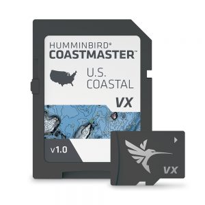
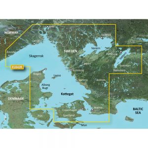
Garmin Navionics+ NSPC028R – Australia, Southeast – Inland & Coastal – Marine Chart

Roll over image to zoom in
Navionics+ NSPC028R – Australia, Southeast – Inland & Coastal – Marine Chart
Get the world’s No. 1 choice in the marine mapping with the best, most up-to-date Navionics®+ cartography on your compatible chartplotter.
Featuring vibrant colors, a streamlined interface and combined coastal/inland content with a popular Navionics® style color palette, Garmin Navionics+ cartography makes it easy to plot your course. Multiple shading options aid in shallow water navigation and make it easy to highlight a target depth range for the best fishing spots. Fully customizable with various chart layers, overlay combinations and up to 10 color-shaded target depth ranges to scope out the best fishing spots.
When you purchase a new Garmin Navionics+ or Garmin Navionics Vision+ cartography product, a one-year subscription is included.
Chart Code – NSPC028R
Coverage Area:
Detailed coverage of the eastern and southern coast of Australia from Brisbane to Nullabor National Park. Coverage includes Tasmania and the ports of Adelaide, Melbourne and Sydney.
Features:
- All-in-one Map Solution – Access detail-rich mapping of coastal features, lakes, rivers and more. Integrated Garmin and Navionics® content offers coverage for boaters worldwide.
- Daily Chart Updates – Charts are constantly being enhanced with new and amended content — as many as 5,000 updates are made every day. The one-year included subscription gives you access to daily chart updates via the ActiveCaptain app.
- Auto Guidance+ Technology – Combining the best of Garmin and Navionics automatic routing features, built-in Auto Guidance+ technology1 gives you a suggested dock-to-dock path to follow through channels, inlets, marina entrances and more.
- Depth Range Shading – High-resolution depth range shading lets you select up to 10 color-shaded options and view your designated target depths at a glance.
- Up to 1′ Contours – For improved fishing and navigation, up to 1′ contours provide a clear depiction of bottom structure for improved fishing charts and enhanced detail in swamps, canals, harbors, marinas and more.
- Shallow Water Shading – To give a clear picture of shallow waters to avoid, this feature allows for shading at a user-defined depth.
- ActiveCaptain Community – Community-sourced content provides useful POIs, such as marinas, anchorages, hazards, businesses and more. Get recommendations from boaters with firsthand experience of the local environment.
Compatibility:
- Check the compatibility of Garmin Navionics+ content and features with your GPS chartplotter.
Technical Specifications:
- Format – MicroSD/SD Card
In the Box:
- SD/MSD Card
1Auto Guidance+ is for planning purposes only and does not replace safe navigation operations
*Sold as an Individual
Additional information
| Brand | |
|---|---|
| Country |


