
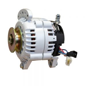
-

-
-
 1 × $23.25
 -
 1 × $22.99
 -
-
 1 × $259.95
 -
 1 × $64.99
 -
 1 × $20.99
 -
 1 × $638.59
 -
-

-
-
-
-

-
-

-
 1 × $109.99
 -
 1 × $126.50
 -
 1 × $12.50
 -
-
 1 × $1,365.00
 -
 1 × $21.99
 -
 1 × $7.58
 -

-
 1 × $18.98
 -
-

-
-
-
-
-
 1 × $59.99
 -

-
-
-
 1 × $125.00
 -
 1 × $1,918.16
 -
-
 1 × $1,633.00
 -
 1 × $289.99
 -
-
-
-
 1 × $232.99
 -
 1 × $249.99
 -
-
 1 × $379.95
 -

-
-
 1 × $127.93
 -
-

-
-
 1 × $753.99
 -
-
 1 × $30.49
 -
-
-
-
-
-
-
-
 1 × $394.90
 -
 1 × $70.00
 -
 1 × $52.25
 -
 1 × $24.49
 -
-
 1 × $919.00
 -
-
 1 × $150.80
 -
 1 × $6,841.38
 -
-
-
 1 × $375.00
 -
-
 1 × $6.99
 -
 1 × $169.00
 -

-
-
-
-
 1 × $128.39
 -
-
 1 × $19.95
 -
-
-
 1 × $1,299.99
 -
 1 × $551.09
 -
-

-
 1 × $145.59
 -

-
-
-
-

-

-
 1 × $3,883.66
 -

-

-
-
-
 1 × $22.99
 -


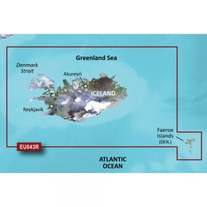
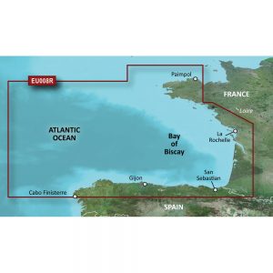
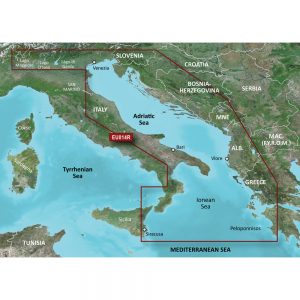
Garmin Navionics+™ NSSA005L – Chile, Argentina & Easter Island – Marine Chart

Roll over image to zoom in
Navionics+™ NSSA005L – Chile, Argentina and Easter Island – Marine Chart
Get the world’s No. 1 choice in the marine mapping with the best, most up-to-date Navionics®+ cartography on your compatible chartplotter.
Featuring vibrant colors, a streamlined interface and combined coastal/inland content with a popular Navionics® style color palette, Garmin Navionics+ cartography makes it easy to plot your course. Multiple shading options aid in shallow water navigation and make it easy to highlight a target depth range for the best fishing spots. Fully customizable with various chart layers, overlay combinations and up to 10 color-shaded target depth ranges to scope out the best fishing spots.
When you purchase a new Garmin Navionics+ or Garmin Navionics Vision+ cartography product, a one-year subscription is included.
Chart Code – NSSA005L
Coverage Area:
Coastal coverage of South America from Arica, Chile to Rio Grande, Brazil. Coverage includes Easter Island, Cape Horn, the Falkland Islands/Islas Malvinas, the South Georgia Islands, the South Sandwich Islands and the Rio de la Plata.
Features:
- All-in-one Map Solution – Access detail-rich mapping of coastal features, lakes, rivers and more. Integrated Garmin and Navionics® content offers coverage for boaters worldwide.
- Daily Chart Updates – Charts are constantly being enhanced with new and amended content — as many as 5,000 updates are made every day. The one-year included subscription gives you access to daily chart updates via the ActiveCaptain app.
- Auto Guidance+ Technology – Combining the best of Garmin and Navionics automatic routing features, built-in Auto Guidance+ technology1 gives you a suggested dock-to-dock path to follow through channels, inlets, marina entrances and more.
- Depth Range Shading – High-resolution depth range shading lets you select up to 10 color-shaded options and view your designated target depths at a glance.
- Up to 1′ Contours – For improved fishing and navigation, up to 1′ contours provide a clear depiction of bottom structure for improved fishing charts and enhanced detail in swamps, canals, harbors, marinas and more.
- Shallow Water Shading – To give a clear picture of shallow waters to avoid, this feature allows for shading at a user-defined depth.
- ActiveCaptain Community – Community-sourced content provides useful POIs, such as marinas, anchorages, hazards, businesses and more. Get recommendations from boaters with firsthand experience of the local environment.
Compatibility:
- Check the compatibility of Garmin Navionics+ content and features with your GPS chartplotter.
Technical Specifications:
- Format – MicroSD/SD Card
In the Box:
- SD/MSD Card
1Auto Guidance+ is for planning purposes only and does not replace safe navigation operations
*Sold as an Individual
Additional information
| Weight | 0.25 lbs |
|---|---|
| Dimensions | 6 × 4 × 1 in |
| Brand | |
| Country |


