
-
-
-
 1 × $1,198.30
 -
 1 × $233.99
 -
 1 × $201.99
 -
 1 × $239.15
 -
 1 × $5,966.00
 -
 1 × $5,839.91
 -
 1 × $16.57
 -
-
 1 × $19.95
 -
 1 × $189.99
 -
 1 × $59.99
 -
-
-
 1 × $29.99
 -
 1 × $114.49
 -

-
 1 × $786.49
 -

-
 1 × $100.00
 -
-
-
 1 × $99.99
 -
-
 1 × $97.46
 -
-
 1 × $38.99
 -
-
 1 × $229.99
 -

-
-
 1 × $129.00
 -

-
-
 1 × $45.95
 -
 1 × $7.76
 -
-

-
 1 × $8.99
 -
-
-
-
-
 2 × $378.98
 -
-
-
-
 1 × $319.99
 -
-
 1 × $40.99
 -
-
-
 1 × $8.99
 -
 1 × $209.95
 -
 1 × $26.99
 -
 1 × $379.24
 -

-
-
-
 1 × $58.35
 -
 1 × $386.88
 -
 1 × $284.99
 -

-
-

-
-
-
 1 × $79.99
 -
-
-
 1 × $23.99
 -
-
-
 1 × $12.68
 -
-

-
-
 1 × $146.99
 -
-
 1 × $199.00
 -
-
-
 1 × $444.99
 -

-
-

-
-
 1 × $35.00
 -
-
-
 1 × $70.49
 -
 1 × $23.00
 -
 1 × $14.69
 -
 1 × $16.53
 -
-
-
-
 1 × $8.99
 -
-

-
 1 × $6.99
 -
 1 × $300.00
 -
 1 × $259.95
 -

-
 1 × $99.00
 -

-
 1 × $103.49
 -
 1 × $251.61
 -
-
-
 1 × $8.99
 -
 1 × $42.99
 -
-

-
-
 1 × $30.00
 -
-
 1 × $219.99
 -
 1 × $374.99
 -
-
-
 1 × $452.52
 -
-

-
 1 × $408.84
 -
-
 1 × $1,505.00
 -
-
-
 1 × $3,796.00
 -
-
-

-

-
-

-
 1 × $1,380.39
 -
 1 × $10.99
 -

-
-
 1 × $6.49
 -

-
-
-
 1 × $455.00
 -
 1 × $665.34
 -
 1 × $18.99
 -
-
-
-
 1 × $32.98
 -
 1 × $147.01
 -

-
 1 × $1,063.02
 -

-
 1 × $1,805.00
 -
-
-
-
 1 × $468.86
 -
 1 × $32.99
 -
-

-
-
 1 × $84.33
 -


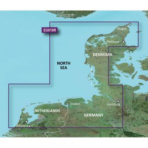
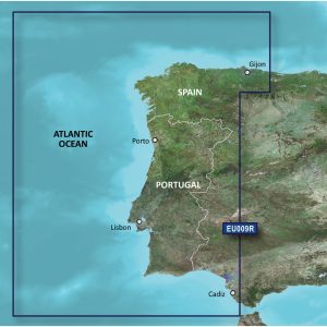
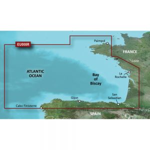
Garmin Navionics Vision+ NVAE018R – Yellow Sea- Marine Chart

Roll over image to zoom in
Navionics Vision+ NVAE018R – Yellow Sea- Marine Chart
Get the world’s No. 1 choice in the marine mapping with the best, most up-to-date Navionics®+ cartography on your compatible chartplotter.
Featuring vibrant colors, a streamlined interface and combined coastal/inland content with a popular Navionics® style color palette, Garmin Navionics+ cartography makes it easy to plot your course. Multiple shading options aid in shallow water navigation and make it easy to highlight a target depth range for the best fishing spots. Fully customizable with various chart layers, overlay combinations and up to 10 color-shaded target depth ranges to scope out the best fishing spots.
When you purchase a new Garmin Navionics+ or Garmin Navionics Vision+ cartography product, a one-year subscription is included.
Chart Code – NVAE018R
Coverage Area:
Coastal coverage of the East Asian coast from Vladivostok, RU to Shanghai, CH including the Korean Peninsula. Coverage includes the ports of Busan, South Korea and Dalian, China.
Features:
- All-in-one Map Solution – Access detail-rich mapping of coastal features, lakes, rivers and more. Integrated Garmin and Navionics® content offers coverage for boaters worldwide.
- Daily Chart Updates – Charts are constantly being enhanced with new and amended content — as many as 5,000 updates are made every day. The one-year included subscription gives you access to daily chart updates via the ActiveCaptain app.
- Auto Guidance+ Technology – Combining the best of Garmin and Navionics automatic routing features, built-in Auto Guidance+ technology1 gives you a suggested dock-to-dock path to follow through channels, inlets, marina entrances and more.
- Depth Range Shading – High-resolution depth range shading lets you select up to 10 color-shaded options and view your designated target depths at a glance.
- Up to 1′ Contours – For improved fishing and navigation, up to 1′ contours provide a clear depiction of bottom structure for improved fishing charts and enhanced detail in swamps, canals, harbors, marinas and more.
- Shallow Water Shading – To give a clear picture of shallow waters to avoid, this feature allows for shading at a user-defined depth.
- ActiveCaptain Community – Community-sourced content provides useful POIs, such as marinas, anchorages, hazards, businesses and more. Get recommendations from boaters with firsthand experience of the local environment.
- High Resolution Satellite Imagery – Downloadable high-resolution satellite imagery provides superior situational awareness.
- Aerial Photography – Crystal-clear aerial and surface photos of ports, marinas, bridges, docks, boat ramps, dams and navigational landmarks provide a better sense of your surroundings above the waterline.
- 3D Fisheye View – This underwater perspective shows 3D representation of bottom and contours as seen from below the waterline. Interface with sonar data for a customized view.
- 3D Marinereye View – This view provides a 3D representation of the surrounding area both above and below the waterline.
- Dynamic Lake Level – Adjust your maps to the lake’s current water levels to see if spots are accessible or too shallow to explore.
Compatibility:
- Check the compatibility of Garmin Navionics+ content and features with your GPS chartplotter.
Technical Specifications:
- Format – MicroSD/SD Card
In the Box:
- SD/MSD Card
1Auto Guidance+ is for planning purposes only and does not replace safe navigation operations
*Sold as an Individual
Additional information
| Weight | 1 lbs |
|---|---|
| Dimensions | 6 × 4 × 2 in |
| Brand | |
| Country |


