
-
 1 × $4.80
 -
-

-
-
 1 × $477.13
 -

-
-

-
-
 1 × $52.00
 -
 1 × $1,013.84
 -
 1 × $115.06
 -
 1 × $13.38
 -
-
-
 1 × $65.99
 -

-
-
 1 × $209.95
 -
-

-
-
-
-
 1 × $734.28
 -
-

-
-
-
-
 1 × $54.00
 -
 1 × $11.99
 -
 1 × $115.01
 -
-
-
-
-
-
 1 × $2,519.99
 -
-
 1 × $411.00
 -
-
 1 × $78.99
 -
 1 × $7,634.30
 -

-
 1 × $595.00
 -
 1 × $127.93
 -
-
 1 × $65.99
 -

-
-
 1 × $72.99
 -
 1 × $154.37
 -
 1 × $429.95
 -
-
 1 × $149.94
 -

-
-
-
-
 1 × $20.99
 -

-
-
 1 × $889.00
 -
-
 1 × $498.27
 -
 1 × $109.99
 -
-
-
 1 × $111.99
 -

-
-
 1 × $12.72
 -
 1 × $64.99
 -
 1 × $48.00
 -
-
-
 1 × $484.16
 -
 1 × $1,487.95
 -
 1 × $175.00
 -

-

-

-
-
-
 1 × $144.99
 -

-
 1 × $918.95
 -
 1 × $12.49
 -
-
 1 × $27.20
 -
-
 1 × $481.58
 -
-
-
-

-
-
 1 × $64.99
 -
 1 × $17.49
 -

-
 1 × $41.99
 -
-
 1 × $56.99
 -
 1 × $12.62
 -

-
-
 1 × $14.99
 -
-
 1 × $60.99
 -
-
-
-
 1 × $99.00
 -
-
-
 1 × $96.49
 -

-
-
-
-
-
 1 × $22.99
 -
-

-
-
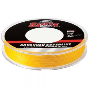
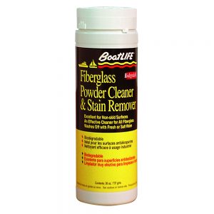
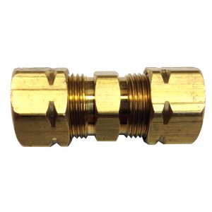
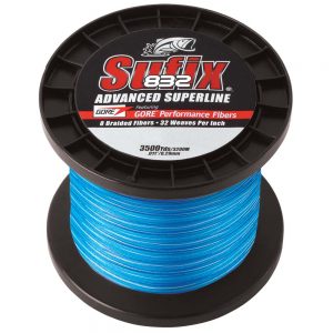
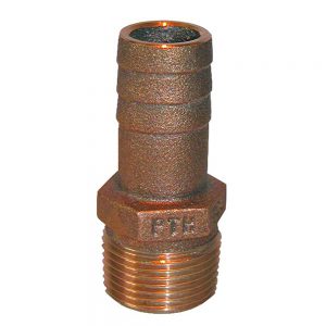
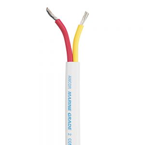
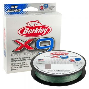
 1 × $8.99


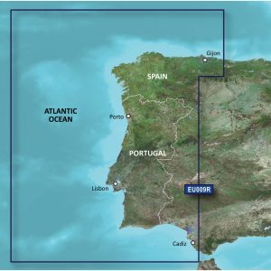
Navionics Vision+™ NVEU620L Greenland & Iceland
Get the world’s No. 1 choice in marine mapping with the best, most up-to-date Navionics®+ cartography on your compatible chartplotter.
Featuring vibrant colors, a streamlined interface, and combined coastal/inland content with a popular Navionics® style color palette, Garmin Navionics+ cartography makes it easy to plot your course. Multiple shading options aid in shallow-water navigation and make it easy to highlight a target depth range for the best fishing spots. Fully customizable with various chart layers, overlay combinations, and up to 10 color-shaded target depth ranges, users can scope out the best fishing spots.
When you purchase a new Garmin Navionics+ or Garmin Navionics Vision+ cartography product, a one-year subscription is included.
Chart Code – NVEU620L
Coverage Area:
Detailed coverage of Greenland, Iceland, the Faeroe Islands, the Shetland Islands, the Orkney Islands, and the northern tip of Britain. Coverage includes Godhavn (Qeqertarsuaq) and Godthab (Nuuk), Greenland; Reykjavik and Akureyri, Iceland; Torshavn, Lerwick, Stromness, Kirkwall, and Thurso, United Kingdom.
Features:
- All-in-one Map Solution – Access detail-rich mapping of coastal features, lakes, rivers, and more. Integrated Garmin and Navionics® content offers coverage for boaters worldwide.
- Daily Chart Updates – Charts are constantly being enhanced with new and amended content — as many as 5,000 updates are made daily. The one-year included subscription gives you access to daily chart updates via the ActiveCaptain app.
- Auto Guidance+ Technology – Combining the best of Garmin and Navionics automatic routing features, built-in Auto Guidance+ technology1 gives you a suggested dock-to-dock path to follow through channels, inlets, marina entrances, and more.
- Depth Range Shading – High-resolution depth range shading lets you select up to 10 color-shaded options and view your designated target depths at a glance.
- Up to 1′ Contours – For improved fishing and navigation, up to 1′ contours provide a clear depiction of bottom structure for improved fishing charts and enhanced detail in swamps, canals, harbors, marinas, and more.
- Shallow Water Shading – To give a clear picture of shallow waters to avoid, this feature allows for shading at a user-defined depth.
- ActiveCaptain Community – Community-sourced content provides useful POIs, such as marinas, anchorages, hazards, businesses, and more. Get recommendations from boaters with firsthand experience of the local environment.
- High-Resolution Relief Shading – This downloadable shading feature combines color and shadow to give you an easy-to-interpret, clearer view of the bottom structure than contour lines alone.
- High-Resolution Satellite Imagery – Downloadable high-resolution satellite imagery provides superior situational awareness.
- Aerial Photography – Crystal-clear aerial and surface photos of ports, marinas, bridges, docks, boat ramps, dams, and navigational landmarks provide a better sense of your surroundings above the waterline.
- 3D Fisheye View – This underwater perspective shows a 3D representation of the bottom and contours from below the waterline. Interface with sonar data for a customized view.
- 3D Marinereye View – This view provides a 3D representation of the surrounding area above and below the waterline.
- Dynamic Lake Level – Adjust your maps to the lake’s current water levels to see if spots are accessible or too shallow to explore.
Compatibility:
- Check the compatibility of Garmin Navionics+ content and features with your GPS chartplotter
Technical Specifications:
- Format – MicroSD/SD Card
In the Box:
- SD/MSD Card
1Auto Guidance+ is for planning purposes only and does not replace safe navigation operations
2Raster cartography cannot be viewed on echoMAP™ CHIRP and ECHOMAP™ Plus combos but can be viewed on mobile devices via the ActiveCaptain mobile app
*Sold as an Individual
Additional information
| Weight | 0.15 lbs |
|---|---|
| Dimensions | 6 × 4 × 1 in |
| Brand |


