-
-

-
 1 × $679.00
 -
-
 1 × $849.00
 -
 1 × $47.50
 -
-
 1 × $59.99
 -
-
 1 × $209.99
 -
 1 × $1,154.99
 -
-
-
-
 1 × $60.00
 -
-
 4 × $1,012.15
 -
-
-
 1 × $762.99
 -
 1 × $117.00
 -
 1 × $1,045.85
 -
 1 × $2,081.50
 -
-
-
-
-
 1 × $117.00
 -

-
 1 × $88.49
 -
-
 1 × $449.00
 -
-
-
-

-
 1 × $281.99
 -
-
-
-
 1 × $1,451.95
 -
 1 × $80.00
 -
 2 × $1,938.70
 -
 1 × $1,691.00
 -
 1 × $79.99
 -
 1 × $475.00
 -
 1 × $259.95
 -
 1 × $149.00
 -
-
 1 × $60.00
 -

-

-
 1 × $179.99
 -
 1 × $1,671.88
 -
-
 1 × $1,012.15
 -

-
-
-
 1 × $52.75
 -
 1 × $541.75
 -
 1 × $479.99
 -
-
 1 × $99.95
 -
 1 × $119.99
 -
-
 1 × $1,399.00
 -
 1 × $4.88
 -
 1 × $329.00
 -
 1 × $4,001.99
 -
-
 1 × $469.99
 -
 1 × $109.99
 -
 1 × $379.99
 -
-
-
-
 1 × $785.00
 -

-
-

-
 1 × $2,039.49
 -
 1 × $85.00
 -
 1 × $31.99
 -
-
-
-
-
 1 × $39.99
 -
-
 1 × $15.98
 -

-
-
-
-
 1 × $795.00
 -
-
-

-
-
 1 × $75.00
 -
-

-
-

-
-
 1 × $190.00
 -


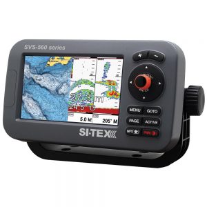
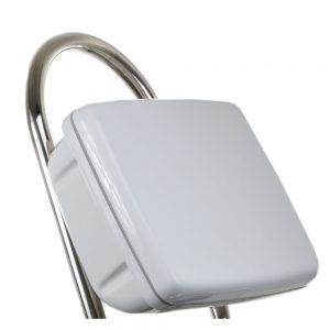
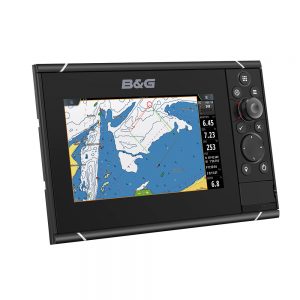
Lowrance Elite FS 7 Chartplotter/Fishfinder with HDI Transom Mount Transducer

Roll over image to zoom in
Elite FS 7 Chartplotter/Fishfinder with HDI Transom Mount Transducer
The Elite Fishing System (FS) combines the power of Lowrance’s proven and newest fishfinding tools with a more affordable display that’s easier to use and install. From ActiveTarget™ live sonar and extreme high-resolution Active Imaging™ with Lowrance CHIRP sonar, SideScan and DownScan Imaging™ to preloaded C-MAP® Contour+ Fishing Maps, Elite FS gives you all the tools you need to find and catch more fish.
Key Features
- 7″ Display
- ActiveTarget™ Live Sonar ready with optional ActiveTarget™ live sonar and transducer (000-15593-001)
- Includes HDI transducer with Lowrance CHIRP and DownScan Imaging™
- FishReveal™
- Preloaded C-MAP® Contour+ with 1-foot contours on 8,900 lakes
- Other mapping options including C-MAP, Navionics® and more
- C-MAP® Easy Routing, Navionics® Autorouting capability
- C-MAP Genesis Live onscreen mapping
- High-resolution multi-touch touchscreen
- Integrated wireless, NMEA 2000® and Ethernet connectivity
- Full touchscreen control of Power Pole® anchors and Ghost® Trolling Motor
C-Map Contour+ Mapping Preloaded
You will spend more time trying to catch fish and less time trying to find them with the high-resolution detail of the C-MAP Contour+ charts built into Elite FS displays. From finding key fishing areas, like ledges, drop-offs and ditches to navigating with precision to fish-holding areas, you will have more success on the water with high-resolution 1-foot contours on 8,900 lakes.
Key Features
- Custom depth shading
- Easy routing, Lowrance presentation for icons
- High-Resolution, Bathymetric 1-foot contours on 8,900 U.S. lakes
- Standard navigation data
- Fishing POIs