
-
-
 1 × $45.00
 -
-

-
 1 × $617.17
 -
-
-
 1 × $12.68
 -
 1 × $109.99
 -
-
-
 1 × $324.50
 -

-

-
 1 × $141.44
 -
-
-
-
-
-
 1 × $31.99
 -
 1 × $14.95
 -
-
-

-
 1 × $9.99
 -
-
 1 × $899.99
 -
 1 × $159.99
 -

-
 1 × $102.76
 -
 2 × $44.99
 -
-
 1 × $379.95
 -
 1 × $684.99
 -
 1 × $6.75
 -
 1 × $149.00
 -
 1 × $255.16
 -
-
 2 × $65.00
 -
-

-

-
-
-
-
-

-
 1 × $49.99
 -

-
-
 1 × $219.99
 -

-
 1 × $27.29
 -
-
-
 1 × $22.95
 -
 1 × $20.91
 -
-
-
-
 1 × $2,153.56
 -
-
 1 × $425.00
 -
-
-
 1 × $58.35
 -
 1 × $199.99
 -
-
-
 1 × $69.49
 -
 1 × $9.49
 -
-
 1 × $762.99
 -
-
-
 1 × $26.99
 -
-
 1 × $209.14
 -
 1 × $33.00
 -

-
-
-
-

-
 1 × $1,784.99
 -
 1 × $1,633.00
 -
-
-
-
 1 × $80.00
 -
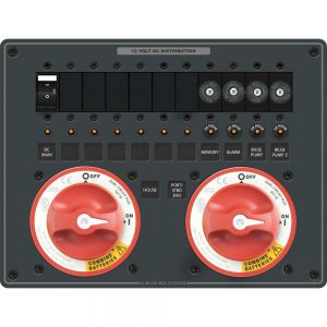
 1 × $527.95
 -
 1 × $159.95
 -
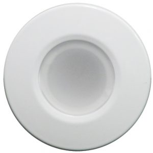
 1 × $11.25
 -
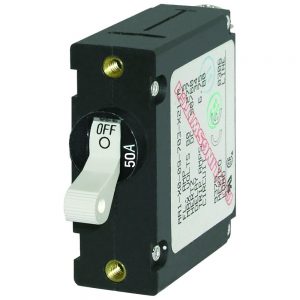
 1 × $540.00
 -
-
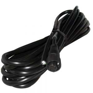
 1 × $199.00


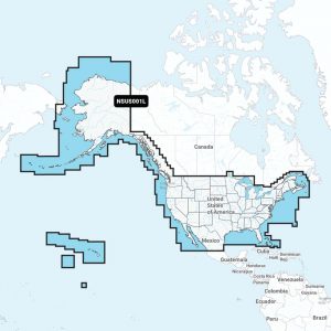
C-MAP 4D PC-D203 Carolinas, Kiribati, Marshall & Marianas

Roll over image to zoom in
4D PC-D203 Carolinas, Kiribati, Marshall & Marianas
C-MAP 4D MAX+ is the latest evolution of electronic charting technology, combining award-winning vector chart data with exclusive Dynamic Raster Charts and the ability to view charts in 2D or amazing 3D presentation with high-resolution satellite imagery. Packed with innovative features designed to enhance every cruising, fishing, or sailing experience.
Features:
- Full-Featured Vector Charts – Provides a wealth of chart detail with the versatility to customize data layers and how they are viewed.
- Dynamic Raster – Traditional “paper chart” look with the unique ability to access information on buoys, lights, and other details. (Exclusive to 4D Max+)
- 3D View – Stunning three-dimensional views of land elevation and bottom contours bring the world around (and under) your boat to life. (Exclusive to 4D Max+)
- Satellite – High-resolution satellite imagery provides real-world reference and enhances situational awareness for coastal navigation. (Exclusive to 4D Max+)
- High-Resolution Bathy Data – The highest available detail of underwater pinnacles, ledges, and canyons that are magnets for offshore and coastal gamefish. Normally an additional purchase ($99 for Wide, $39 for Local), High-Resolution Bathy Data is now included in the price.
- Sport Fishing Data – Provides angling intelligence for wrecks and reefs, Fish ID photos, fishing tips, updated regulations, state records, and more. Normally an additional purchase ($49 for Wide, $19 for Local), Sport Fishing Data is now included in the price.
- Easy Routing – Automatically plots the shortest, safest route based on detailed chart data and user’s vessel information. *Easy Routing is not available in the U.S. on the Humminbird product. (Exclusive to 4D Max+)
- Tides and Currents – interactive on-screen tide graphs and current arrow.
- Aerial Photos – Aerial pictures of harbor entrances, channels, and marinas.
- Guardian Alarms – Search and receive alerts for rocks, obstructions, shallows depths and other navigation hazards.
- Multi-Language Charts – More than 140 languages can be displayed using native character sets.
Additional information
| Weight | 0.1 lbs |
|---|---|
| Dimensions | 6 × 4 × 1 in |
| Brand |


