
-
-

-
-
-
 1 × $3,245.00
 -
 1 × $214.29
 -
-
-

-
-
-
 1 × $148.67
 -
-
 1 × $8.99
 -
-
 1 × $24.95
 -
-
-
-
-
 1 × $1,488.06
 -

-
 1 × $29.99
 -
-
-

-
-
 1 × $360.99
 -
 1 × $315.00
 -
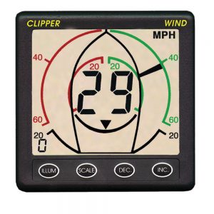
 1 × $918.95
 -
-
 1 × $139.00
 -
-
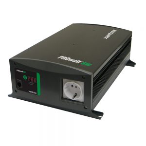
 1 × $599.99
 -

-

-
-
-
-
-
-
 1 × $1,390.00
 -
-
 1 × $40.10
 -
 1 × $43.95
 -
-
-
 1 × $22.99
 -
 1 × $82.95
 -
-

-
-
 1 × $33.99
 -
-
 1 × $17.75
 -
 1 × $11.98
 -
 1 × $280.40
 -
-
 1 × $30.99
 -
 1 × $5.49
 -
-
-
-
-
 1 × $175.00
 -
 1 × $39.99
 -
 1 × $108.76
 -
-
-

-
 1 × $5,590.00
 -
-
-
 1 × $770.00
 -
 1 × $380.70
 -

-
 1 × $98.99
 -
-
-

-

-
 1 × $81.76
 -
-
 1 × $65.99
 -
-

-
-
 1 × $22.99
 -

-
-
-

-
 1 × $930.99
 -
-
 1 × $1,249.99
 -
 1 × $464.99
 -
-
 1 × $300.00
 -
 1 × $198.45
 -
-
-
-
-

-
 1 × $109.99
 -
 1 × $89.99
 -
 Airmar B117 Traditional/CW Thru‑Hull 50/200kHz, 600W, Transducer, 9-Pin, DT f/Simrad, Lowrance & B&G1 × $289.00
 -
-
 1 × $900.00
 -
-
 1 × $1,295.00
 -
 1 × $1,199.99
 -
-

-

-
-
 1 × $1,115.56
 -

-
-

-

-
 1 × $59.08
 -
 1 × $1,104.56
 -
-
-
 1 × $1,189.99
 -
-
-
-
-

-
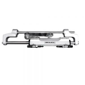
 1 × $1,699.00
 -
 1 × $37.95
 -
-
 1 × $29.81
 -

-
-
 1 × $87.00
 -
-
 1 × $5,590.00
 -

-
 1 × $14.04
 -
-
-

-
 1 × $142.63
 -

-
-
 1 × $39.99
 -
-
-
 1 × $32.99
 -
-
 1 × $18.25
 -
-
-

-
-
-
-
-

-
-

-
-
 1 × $162.00
 -

-
 1 × $23.99
 -
-

-

-

-
 1 × $11.98
 -
-
-
-
-
 1 × $7.58
 -
-
 1 × $178.40
 -
 1 × $21.27
 -
 1 × $12.99
 -
-
-
-
 1 × $153.43
 -

-

-
 1 × $72.99
 -
 1 × $11.00
 -
 1 × $10.99
 -
 1 × $99.95
 -

-
 1 × $45.99
 -
 1 × $1,140.57
 -
 1 × $29.96
 -
 1 × $82.06
 -
 1 × $137.75
 -
-
 1 × $94.99
 -

-
-

-
-
-


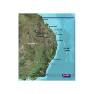
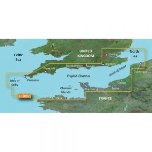
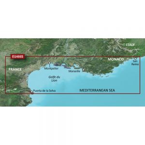
Garmin Navionics Vision+™ NVEU646L Europe, Central & West

Roll over image to zoom in
Navionics Vision+™ NVEU646L Europe, Central & West
Get the world’s No. 1 choice in marine mapping with the best, most up-to-date Navionics®+ cartography on your compatible chartplotter.
Featuring vibrant colors, a streamlined interface, and combined coastal/inland content with a popular Navionics® style color palette, Garmin Navionics+ cartography makes it easy to plot your course. Multiple shading options aid in shallow-water navigation and make it easy to highlight a target depth range for the best fishing spots. Fully customizable with various chart layers, overlay combinations, and up to 10 color-shaded target depth ranges, users can scope out the best fishing spots.
When you purchase a new Garmin Navionics+ or Garmin Navionics Vision+ cartography product, a one-year subscription is included.
Chart Code – NVEU646L
Coverage Area:
Detailed coverage of central and western Europe. Coverage includes the European coast from the Szczecin Lagoon to Monaco; the Azores; Madeira; the Canary Islands; the Balearics; Corsica and Sardinia; Gibraltar, the English Channel; the Channel Islands; the IJsselmeer; the rivers of France, Germany, and the Low Countries; Lakes Maggiore, Como, Garda, Geneva, Constance, and Balaton.
Features:
- All-in-one Map Solution – Access detail-rich mapping of coastal features, lakes, rivers, and more. Integrated Garmin and Navionics® content offers coverage for boaters worldwide.
- Daily Chart Updates – Charts are constantly being enhanced with new and amended content — as many as 5,000 updates are made daily. The one-year included subscription gives you access to daily chart updates via the ActiveCaptain app.
- Auto Guidance+ Technology – Combining the best of Garmin and Navionics automatic routing features, built-in Auto Guidance+ technology1 gives you a suggested dock-to-dock path to follow through channels, inlets, marina entrances, and more.
- Depth Range Shading – High-resolution depth range shading lets you select up to 10 color-shaded options and view your designated target depths at a glance.
- Up to 1′ Contours – For improved fishing and navigation, up to 1′ contours provide a clear depiction of bottom structure for improved fishing charts and enhanced detail in swamps, canals, harbors, marinas, and more.
- Shallow Water Shading – To give a clear picture of shallow waters to avoid, this feature allows for shading at a user-defined depth.
- ActiveCaptain Community – Community-sourced content provides useful POIs, such as marinas, anchorages, hazards, businesses, and more. Get recommendations from boaters with firsthand experience of the local environment.
- High-Resolution Relief Shading – This downloadable shading feature combines color and shadow to give you an easy-to-interpret, clearer view of the bottom structure than contour lines alone.
- High-Resolution Satellite Imagery – Downloadable high-resolution satellite imagery provides superior situational awareness.
- Aerial Photography – Crystal-clear aerial and surface photos of ports, marinas, bridges, docks, boat ramps, dams, and navigational landmarks provide a better sense of your surroundings above the waterline.
- 3D Fisheye View – This underwater perspective shows a 3D representation of the bottom and contours from below the waterline. Interface with sonar data for a customized view.
- 3D Marinereye View – This view provides a 3D representation of the surrounding area above and below the waterline.
- Dynamic Lake Level – Adjust your maps to the lake’s current water levels to see if spots are accessible or too shallow to explore.
Compatibility:
- Check the compatibility of Garmin Navionics+ content and features with your GPS chartplotter
Technical Specifications:
- Format – MicroSD/SD Card
In the Box:
- SD/MSD Card
1Auto Guidance+ is for planning purposes only and does not replace safe navigation operations
2Raster cartography cannot be viewed on echoMAP™ CHIRP and ECHOMAP™ Plus combos but can be viewed on mobile devices via the ActiveCaptain mobile app
*Sold as an Individual
Additional information
| Weight | 0.15 lbs |
|---|---|
| Dimensions | 6 × 4 × 1 in |
| Brand |


