
-
 1 × $52.99
 -
 1 × $58.35
 -
-
-
 1 × $4,165.00
 -
 1 × $141.44
 -
 1 × $111.99
 -
-
-

-
-
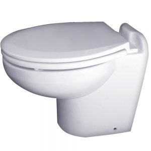 Raritan Marine Elegance - White - Household Style - Freshwater Solenoid - Smart Toilet Control - 12v1 × $1,520.00
 -
-
 1 × $29.99
 -
-
 1 × $120.00
 -
-

-
-
-
-
 1 × $1,392.35
 -
 1 × $715.43
 -
 1 × $22.95
 -
 1 × $165.56
 -
-
-
-
 1 × $120.86
 -
 1 × $289.99
 -
 1 × $9.95
 -
 1 × $1,012.15
 -

-
 1 × $192.99
 -

-
-

-
-
 1 × $114.99
 -
 1 × $36.00
 -
-
-
 1 × $119.99
 -
-
 1 × $98.99
 -

-
-
-
-
 1 × $127.58
 -
 1 × $199.00


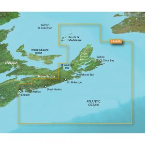
4D Lakes NA-D074 South East
C-MAP charts have long been held in high regard by boaters because they combine aesthetically pleasing vector electronic charts with reliable sources. When buying C-MAP boaters can be assured that the charts they are getting are of the highest standard.
C-Map 4D will provide boaters with charts packed additional features such as raster chart views or Satellite images* to maximize situational awareness.
Coverage Area:
Lakes and major rivers of the South East area of the USA in the states of: Florida, Georgia, Alabama, Tennessee, South Carolina, North Carolina.
Additional information
| Weight | 0.2 lbs |
|---|---|
| Dimensions | 8 × 5 × 1 in |
| Brand |


